
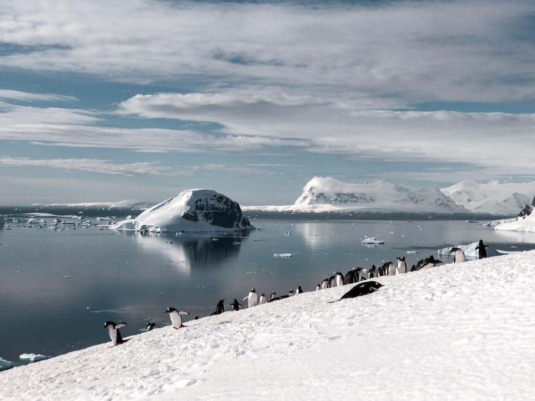
Beneath its icy exterior, Antarctica, a continent known for its ice & seclusion, frequently hides a dramatic secret. Its ancient bedrock reveals a rich & complex geological story that reveals a turbulent past & a dynamic present, even though the sheer size of its glaciers and ice shelves is unquestionably breathtaking. Antarctica is a patchwork of craters, mountain ranges, and volcanic fields that bear witness to billions of years of Earth’s evolution rather than a single, homogeneous block of ice. Discovering these undiscovered geological treasures provides important insights into global plate tectonics, climate history, and even the origins of life, in addition to a deeper understanding of the continent itself. The supercontinent Gondwana, a massive landmass that started to form about 600 million years ago & had a significant impact on the Earth’s continental arrangement for hundreds of millions of years, is intrinsically linked to Antarctica’s geological story.
Its disintegration, which began about 180 million years ago, shaped the landmasses of the modern world & left Antarctica as a key, if remote, component of this enormous geological puzzle. An assortment of provinces. The continent is roughly split into East Antarctica and West Antarctica, each of which has unique geological traits that reflect their disparate evolutionary histories. Ancient Precambrian cratons & related metamorphic and igneous rocks, many of which are older than 2.5 billion years, make up the majority of East Antarctica, the region that is larger & more geologically stable. Some of the oldest continental crust on Earth can be found in these cratons, like the Maudheim Provence and the Napier Complex, which provide insight into the planet’s early history and the processes that created its first land masses.
These prehistoric rocks indicate that East Antarctica was once at the center of Gondwana, creating a crucial nexus where Australia, Africa, India, and South America met. These formations have been mostly hidden by the unrelenting forces of erosion, glaciation, and subsequent ice cover; however, their intricate internal structures and mineral compositions are revealed by exposed nunataks & deep ice-scouring. The West is younger & more dynamic. West Antarctica, on the other hand, is a more tectonically active & geologically younger region. In essence, it is an archipelago of smaller continental blocks, or microplates, joined by a number of mountain belts from the Cenozoic and Mesozoic eras.
These blocks, which include Thurston Island, Marie Byrd Land, and the Antarctic Peninsula, are examples of pieces that broke apart and collided during Gondwana’s disintegration before coming together to form this more fragmented western sector. The rugged peaks of the Transantarctic Mountains & the persistent volcanic activity in areas like Marie Byrd Land are examples of how subduction-related volcanism & active tectonics have dominated West Antarctica’s geological history. Because West Antarctica’s thinner, more dynamic crust makes it more vulnerable to melting & ice sheet collapse, this distinction between East and West Antarctica is essential to comprehending the continent’s various reactions to climate change. Under the Ice: Mineral Treasures. East Antarctica’s ancient provenance, especially in its cratonic regions, promises substantial mineral deposits.
Geological surveys have found encouraging indications of valuable resources, even though extensive mining is currently forbidden and economically unfeasible due to harsh conditions and international treaties. These include coal in the Transantarctic Mountains, iron ore in the Prince Charles Mountains, & even petroleum traces in offshore sedimentary basins. Precious metals like gold, silver, and copper are concentrated by the geological processes that created these old cratons, which frequently involved extreme heat, pressure, and fluid circulation.
| Geological Feature | Location | Type | Size |
|---|---|---|---|
| Wilkes Land Crater | East Antarctica | Impact Crater | Approximately 500 kilometers in diameter |
| Lake Vostok | Underneath the East Antarctic Ice Sheet | Subglacial Lake | One of the largest subglacial lakes in Antarctica, with a surface area of 14,000 square kilometers |
| Ellsworth Subglacial Highlands | West Antarctica | Mountain Range | Rising to over 4,000 meters above sea level |
Given the extensive ice cover, a thorough mapping of the underlying bedrock is necessary to comprehend the distribution and origins of these potential resources. Stretching over 3,500 kilometers across the continent, the Transantarctic Mountains (TAM) are one of the longest mountain ranges on Earth, dominating the landscape and serving as an essential geological boundary. This magnificent range, which is essential to the tectonic development & glacial history of the continent, essentially separates East and West Antarctica. The outcome of uplift & rifting. The TAM is a prime example of rift-flank uplift, in contrast to many mountain ranges created by continental collision.
Their formation is closely related to the rifting that separated East and West Antarctica after Gondwana broke apart, which started about 180 million years ago. The rift system’s flanks were raised as the continental crust thinned & stretched, producing the striking peaks and valleys that can be seen today. Throughout the Cenozoic, different parts of the range experienced uplift episodes at different times, indicating that this uplift was a continuous process rather than a single event.
This extensional and uplifting tectonic regime is demonstrated by the Ross Sea Rift, a steep, fault-bounded eastern face of the TAM. A window into prehistoric climates. The Transantarctic Mountains’ exposed peaks and valleys provide priceless insights into Antarctica’s & the planet’s past climates. Even beneath the ice, U-shaped troughs and valleys sculpted by the glaciers show times of prolonged glaciation.
However, a very different past is revealed by fossil evidence discovered within sedimentary rocks interbedded with volcanic layers. Fossilized plants, such as ferns, mosses, and even ancient forests, have been found alongside dinosaur remains. These findings suggest that Antarctica was much warmer and more vegetated for millions of years prior to the formation of permanent ice sheets.
For paleoclimatologists to reconstruct global climate models and comprehend the processes that ultimately resulted in Antarctica’s freezing, these fossils offer vital information. These mountains’ elevation has also been crucial in capturing atmospheric moisture, which has helped the East Antarctic Ice Sheet expand and endure. Both hydrothermal systems and volcanic activity.
The Transantarctic Mountains are primarily shaped by uplift and erosion, but volcanic activity has also had a big impact, especially in the later stages of their formation. Erebus, the southernmost active volcano on Earth and part of the Ross Sea Rift system, and the Executive Committee Range, a group of volcanoes in West Antarctica, are two clear examples of this magmatic activity. These volcanoes are frequently linked to special hydrothermal systems, in which minerals are dissolved and deposited as superheated water moves through fractured rock.
By supporting extremophile microorganisms that flourish in harsh environments, these systems can produce distinctive ecosystems that provide hints about the possibility of life in other hostile environments on Earth and beyond. The dynamics of the nearby glaciers and ice sheets may be impacted by the heat flux from these systems, which may also affect basal ice melt. West Antarctica is a hotbed of both active & dormant volcanism due to its thinner crust and continuous tectonic activity. The geomorphology, climate, and even biological diversity of the continent are all significantly impacted by this fiery underworld beneath the ice.
The West Antarctic Rift System is a blazing arc. One of the biggest active continental rifts on Earth, the West Antarctic Rift System (WARS) is distinguished by vast volcanic fields, active faults, and significant heat flow. Though at a slow geological pace, this thousands-kilometer-long rift system is essentially tearing apart West Antarctica. The majority of the volcanoes in this rift system, such as those on the Antarctic Peninsula & Marie Byrd Land, are basaltic, reflecting the upwelling of mantle material as the crust expands and thins.
Even though they are frequently concealed by thousands of meters of ice, these eruptions have a big effect on the ice sheets that cover them. Localized melting brought on by subglacial eruptions can create subglacial lakes and affect the rate of ice flow, which may increase the instability of ice sheets. Scientists map and track the activity of these hidden volcanic landscapes using seismic surveys and aerial radar.
Mount Erebus is the symbol. Mount Erebus, the most active volcano in Antarctica and one of the most researched, stands majestically atop Ross Island. Volcanologists have a constant laboratory thanks to its frequent ash plumes, fumaroles, and persistent fife—a rare phenomenon in which a lava lake stays molten for extended periods of time.
Erebus is an important location for learning about the formation and evolution of magma in extensional environments because of its distinctive geological setting, which includes a rift system and a comparatively alkaline magma composition. Erebus’s heat sustains a variety of microbial communities in its ice caves and around its fumaroles, demonstrating the adaptability of life in harsh conditions. Because the heat and ash deposition from the volcano directly affect the surrounding ice & snow, studying Erebus also aids scientists in understanding how volcanic activity and glacial ice interact.
effects on glaciers and ice sheets. The stability of the West Antarctic Ice Sheet (WAIS) is significantly impacted by widespread volcanism in West Antarctica. The base of the ice sheet may be melted by geothermal heat flux from subglacial volcanoes & the larger WARs, lubricating its motion and accelerating ice flow.
Subglacial lake formation, which is frequently fueled by geothermal heat, can have a significant impact on ice dynamics. Abrupt drainage events have the potential to destabilize sizable portions of the ice sheet. Also, even subglacial ash eruptions can change the ice surface’s albedo after they are exposed, increasing solar radiation absorption & melt.
Therefore, it is essential to comprehend the distribution, activity, and heat output of these hidden volcanoes in order to forecast how the West Antarctic Ice Sheet will behave in the future and how it will contribute to sea level rise. In order to identify subglacial volcanic heat signatures & track alterations in ice sheet dynamics associated with geothermal activity, remote sensing methods such as satellite imagery and aerial radar are constantly being improved. A vast and complex network of subglacial lakes, a unique hydrological system that is still mostly unexplored, is located beneath the enormous weight of the Antarctic ice sheets. With kilometers of ice separating them from the surface, these hidden bodies of water represent pristine, ancient environments that may be teeming with new life forms and contain priceless hints about Earth’s past. Lake Vostok is the legacy of Russia.
Our knowledge of subglacial environments was completely transformed in the 1990s when Russian scientists discovered Lake Vostok, which is situated almost 4 kilometers below the East Antarctic Ice Sheet. This enormous lake, which is about the size of Lake Ontario, is a special laboratory for researching biogeochemical processes in complete isolation because it has been cut off from the atmosphere for millions of years. Although there are many environmental concerns associated with drilling through the ice to reach the lake, the process has produced intriguing hints about its microbial inhabitants, providing insights into early Earth life & possibly even extraterrestrial life.
The geological processes taking place beneath the ice, such as interactions with subglacial bedrock and geothermal heat flux, can be inferred from the lake’s water chemistry and isotopic composition. A Growing Freshwater System Network. Over 400 subglacial lakes have been identified throughout the continent since Lake Vostok was first discovered. Beneath the ice, these lakes form an interconnected hydrological network with a wide range of sizes and depths.
The dynamics of ice sheets can be affected by the water flow between these lakes; large-scale drainage events have the potential to cause abrupt changes in ice flow & even aid in the collapse of ice shelves. These lakes’ distribution & geometry are closely related to the underlying geology and topography, with deeper basins frequently storing more meltwater. Understanding the overall mass balance of the ice sheets & how they react to shifting climatic conditions depends on a thorough mapping of these subglacial systems. Hotspots of biogeochemistry.
Subglacial lakes have conditions that are unlike anything else on Earth because of their extreme pressure, complete darkness, low nutrient availability, and continuous lack of fresh atmospheric input. These lakes’ microbial communities have developed to survive in these hostile environments, frequently depending on chemosynthesis and geological energy sources rather than sunlight. Researching these extremophiles provides information about the boundaries of life and the possibility of life in comparable settings on other planets or moons, like Europa or Enceladus.
A proxy record of previous climate shifts and the geological development of the underlying bedrock over millions of years can be obtained from the chemical makeup of the lake waters & the sediment cores that are taken from them. Sophisticated aseptic drilling and sampling techniques have been developed in order to ensure that these environments remain pristine during exploration. Antarctica’s rich geological past provides important insights into the paleogeography of the planet & may contain enormous resources that are currently unreachable. The same forces that formed this continent billions of years ago still have an impact on our planet today.
The reconstruction of ancient continents. In order to reconstruct the ancient supercontinents of Rodinia & Gondwana, the intricate pattern of Antarctic cratons and mountain belts is essential. Geologists can piece together the jigsaw puzzle of plate tectonics and comprehend how landmasses have drifted, collided, and split over billions of years by comparing geological formations, rock types, and fossil records with those of other continents.
For example, the Dronning Maud Land’s geology strikingly resembles southern Africa’s geological features, lending credence to the notion of a shared continental past. Accurate models of Earth’s climate history, ocean currents, and the distribution of life throughout geological time depend on an understanding of previous continental configurations. Ocean floor insights. There may be enormous hydrocarbon reserves in the sedimentary basins that encircle Antarctica, especially beneath the continental shelf.
Over millions of years, organic matter accumulated in these basins during Gondwana’s rifting and breakup. Even though resource extraction is currently forbidden by international treaties, scientific research into these basins yields important insights into ocean circulation patterns, paleoclimate, and marine life evolution. Microfossils and geochemical signatures found in sediment cores taken from these offshore areas indicate significant changes in the world’s climate, such as the start of Antarctic glaciation and varying ice sheet sizes. Predicting future climate scenarios requires an understanding of these historical climate changes. Glacial erosion’s role.
Antarctica’s geological marvels have been both hidden and revealed by the immense force of glacial erosion. The movement of glaciers carves deep valleys, reveals ancient bedrock in nunataks, & carries a massive amount of debris, all while covering vast areas with thick ice. These glacial erratics, which are rocks that have been carried far from their original location, can reveal information about the subglacial landscape’s geological makeup.
Along the coastlines and inside the Transantarctic Mountains, striking fjords and U-shaped valleys have also been sculpted by the ice sheets’ sheer erosive power. Geologists can better understand the long-term relationship between ice, rock, and climate by examining patterns of glacial erosion and deposition. This knowledge is essential for understanding Antarctica’s past and future. The internal architecture of mountain ranges and cratons that would otherwise be hidden is revealed by these old erosional features, which also act as natural cross-sections through intricate geological structures.
To sum up, although Antarctica is sometimes thought of as a boring white wilderness, it actually contains a wealth of geological marvels. Its fractured foundation reveals billions of years of Earth’s evolution, from the volcanic dynamism of West Antarctica to the ancient cratons of East Antarctica. A story of unmatched geological richness is created by the majestic Transantarctic Mountains, the enigmatic depths of subglacial lakes, and the flaming breath of hidden volcanoes. The hidden geological treasures of Antarctica will surely continue to provide important insights into the past, present, & future of our planet as long as scientific exploration is carried out using cutting-edge remote sensing and drilling technologies.
The continent’s distinctive geological fabric acts as a vital natural laboratory, providing unmatched chances to comprehend planetary processes, evaluate the effects of climate change, and even look for the beginnings and boundaries of life.
.
FAQs
What is the hidden geological feature in Antarctica?
The hidden geological feature in Antarctica is a massive, ancient mountain range buried beneath the ice. This mountain range is believed to be as tall as the Alps and as long as the Andes.
How was the hidden geological feature discovered?
The hidden geological feature was discovered using satellite data and radar technology. Scientists were able to map the terrain beneath the ice and uncover the existence of this ancient mountain range.
What is the significance of the hidden geological feature in Antarctica?
The discovery of the hidden geological feature in Antarctica provides valuable insights into the geological history of the continent. It also has implications for understanding how the ice sheet and climate have evolved over time.
What impact does the hidden geological feature have on the environment?
The hidden geological feature in Antarctica has the potential to influence the flow of ice and water across the continent. Understanding its presence and structure is important for predicting how the ice sheet may respond to climate change.
What are the future research implications of the hidden geological feature in Antarctica?
Future research on the hidden geological feature in Antarctica will focus on understanding its impact on ice dynamics, climate, and the overall geological history of the continent. This discovery opens up new avenues for scientific exploration and study.









Leave a Reply